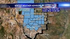

A Winter Weather Advisory has been issued for much of West Texas until midnight. The cold front responsible for the cold and windy weather is also responsible for the rain that has sparked in much of the area. Cold air continues to filter into the region which will aid in snow development as we move into the afternoon hours.
The forecast is a bit tricky because while the cold air mass is enough to sustain snow development, surface temperatures are too warm to allow snow to stick. This is why we might see snow on radar, but not at the surface. In order for snow to stick, the whole column of air between the surface and the clouds needs to be below freezing. As of now, the snow is melting before it reaches the surface.
Temperatures will drop during the afternoon and overnight hours. Additional rain will make the transition to snow for areas along and south of I-20. For the afternoon drive, watch for areas of lower visibility due to the rain and snow. Some areas are expected to get anywhere between a dusting of snow to three inches. The "bulls eye" for snow will be Pecos County near the Stockton Plateau to the counties of Crane and Upton. Snow will stick best on grass as well as bridges and overpasses.
After today's cold snap, West Texas warms to the seventies by this weekend!